

Maritime protection is a chain of decisions
Five questions connecting chokepoint disruption, disaster response, species protection, maritime data and drones.
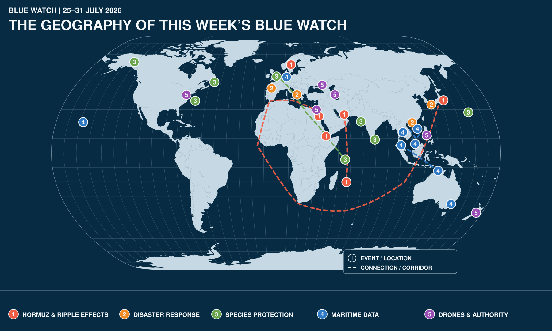
Disclaimer: the map is AI-generated - some dots or routes may not be very precise, but have been retained to show complex links or re-rerouting
1. Hormuz has become a distributed crisis
Question: Who governs the consequences when disruption at one chokepoint reaches crews, ports, fishers and ecosystems thousands of miles away?
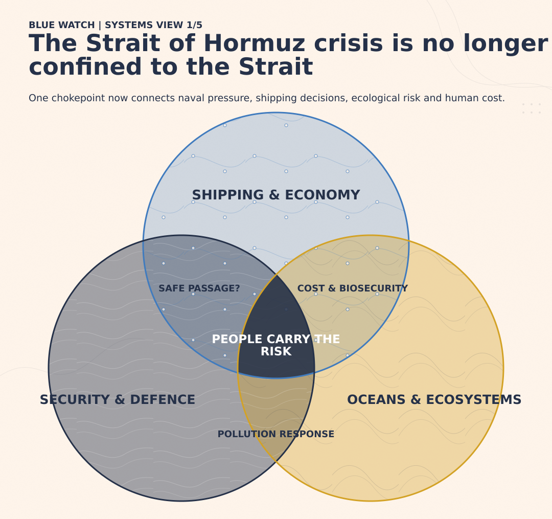
The Blue Watch read
The Strait of Hormuz crisis is increasingly measured through its consequences beyond the Strait: seafarers remain stranded, rare individual transits have yet to restore commercial confidence, fuel costs are reaching European fishing communities, and prolonged vessel lay-up is creating biosecurity risks that could travel with ships when regular traffic resumes.
Signals from the week
The UN human-rights office reported that at least 6,000 seafarers were stranded aboard approximately 400 vessels in and around the Strait. The IMO has called on states to facilitate their safe departure, but no coordinated mechanism has emerged for evacuation, crew changes or repatriation at the required scale.
The QatarEnergy-controlled LNG carrier Al Areesh exited the Strait on 30 July, completing the first publicly visible LNG transit in almost three weeks. One passage offers limited evidence about whether owners, insurers and crews are ready to resume regular operations.
Oman proposed a regional mechanism involving neighbouring and user states to manage passage through Hormuz. Iran rejected regional management and maintained that responsibility should remain with Iran and Oman.
After loading Saudi naphtha at Yanbu for Japan, the Danish-flagged Torm Innovation turned north towards Suez to avoid Bab el-Mandeb. Its diversion via Gibraltar and the Cape of Good Hope could almost triple the voyage time. Passage via the Panama Canal could not be envisaged because the Canal is currently too low and is closed.
The European Commission approved a €149 million Swedish support scheme for agricultural, fishing and aquaculture businesses affected by high fuel prices. A crisis in a distant shipping corridor has become a domestic resilience issue for European coastal communities.
Marine scientists warned that the prolonged lay-up of more than 1,500 vessels could create a potential bio-invasion super-spreader event. Organisms accumulated on hulls could be carried to ports, reefs and fishing grounds when the vessels begin moving again. Biofouling also increases drag, fuel consumption, emissions and operating costs.
Diversions have increased traffic and bunkering activity around Mauritius. Port Louis’s growing strategic importance reinforces the need for effective hull inspection, biofouling management and in-water cleaning capacity.
Satellite imagery identified two oil slicks near Larak Island, including one associated with a tanker damaged during the crisis. Their composition, volume and ecological effects have yet to be verified.
The unresolved issue
The governance of the crisis is divided among actors with different responsibilities and measures of success.
Navies can provide surveillance, escort and mine-countermeasure capacity. Coastal states control traffic arrangements. Shipowners and insurers decide whether vessels sail. Flag states hold responsibilities towards crews. Port authorities manage arrivals, while environmental agencies monitor pollution and biosecurity risks.
No single actor governs the complete chain.
The competing proposals for managing Hormuz expose that fragmentation. Oman’s plan would distribute responsibility across a regional mechanism. Iran’s position would retain control with the two coastal states. Either approach will still depend on acceptance by owners, insurers, crews and the states whose trade passes through the Strait.
Naval availability presents a further constraint. European forces are already balancing passage protection, counter-piracy, flag verification, sanctions-related activity and other standing commitments. Each task requires ships, intelligence, legal expertise and command attention.
The central test is therefore practical: can an arrangement produce sustained commercial movement, support stranded crews, monitor environmental damage and retain the confidence of the people expected to use the route?
2. The sea is part of the emergency plan
Question: Who prepares for the moment when roads, ports, rescue assets and coastal businesses must operate as one system?
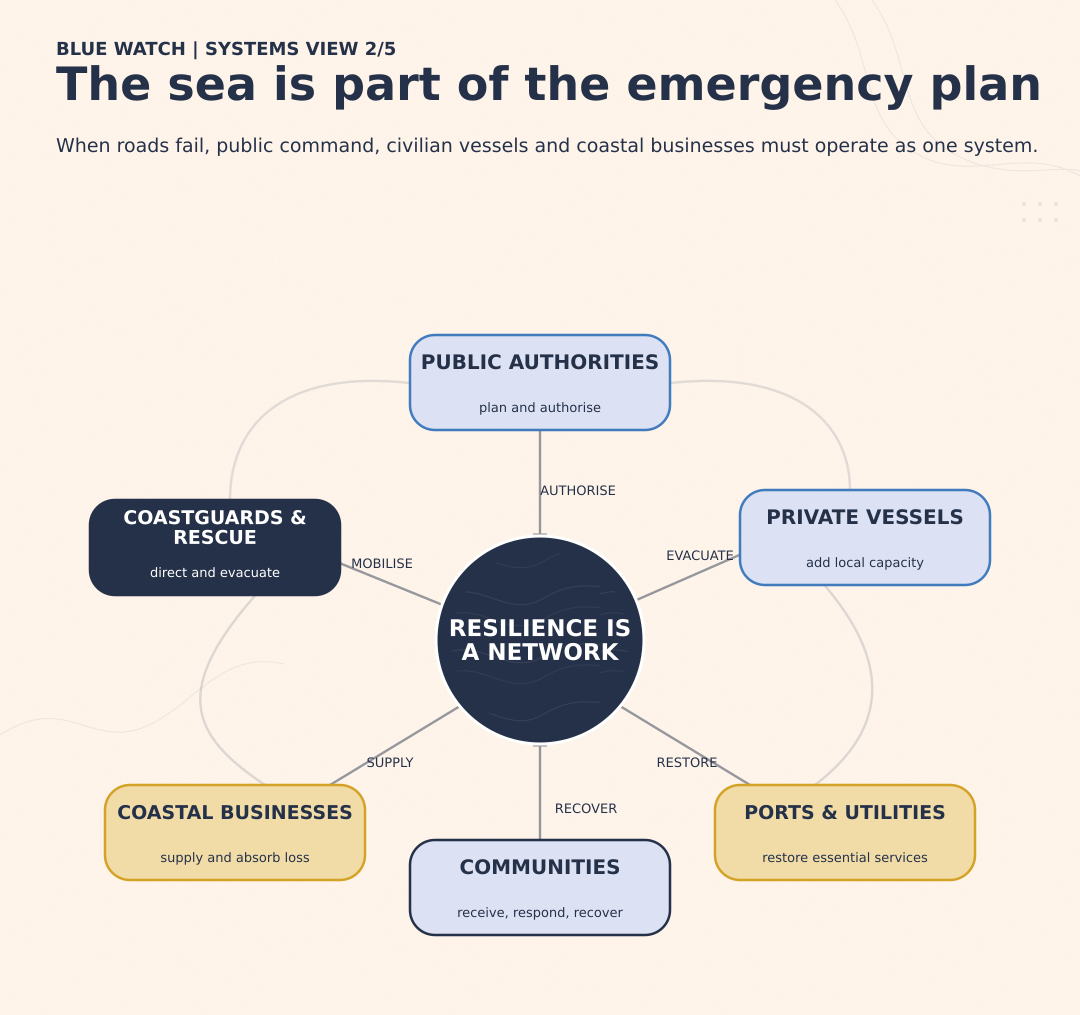
The Blue Watch read
Wildfires in France and Italy turned the sea into an evacuation route when movement by land became unsafe. Public authorities led the operations, but private vessels and coastal businesses supplied part of the capacity. Their contribution reveals how much disaster response depends on local maritime networks, including actors whose operational role and economic exposure may receive little attention in formal plans.
Signals from the week
At Cap Ferret, more than 1,000 people were evacuated by boat as fire threatened a peninsula served by a single main road. Maritime evacuation provided an alternative when land access could no longer be relied upon.
Oyster farmers around Arcachon Bay contributed shelter, food, water, transport and equipment to relief efforts. At the same time, access restrictions prevented many of them from tending, harvesting and selling their oysters.
In Peschici, Italy, Coast Guard vessels, Guardia di Finanza craft and private boats evacuated more than 700 people. The response combined state authority with civilian capacity available locally.
China activated a national emergency response before Typhoon Noul made landfall. Authorities suspended ferry and passenger services, evacuated offshore workers and positioned rescue vessels, helicopters and tugs to protect coastal populations and infrastructure.
Following the earthquake in Japan, the response moved from tsunami precautions towards water supply, cooling, utilities and infrastructure assessment. Self-Defense Forces supported affected communities while ports, fisheries and aquaculture facilities required inspection.
The unresolved issue
Emergency plans are usually organised around institutions. Real emergencies mobilise networks.
Coastguards, navies and civil-protection agencies may direct an operation, but ferry operators, fishing businesses, private boat owners, ports, utilities and local authorities often determine how much capacity is available and how quickly it can be used.
The events in France and Italy raise practical questions. Who is authorised to mobilise private vessels? How are passengers allocated across public and civilian craft? Which communications systems are used? What safety and insurance rules apply? How are operators compensated for damage, lost access or interrupted business?
These questions extend into recovery. Arcachon’s oyster farmers served as relief partners while losing income because they could not reach their farms. A disaster plan that relies on local businesses should also account for their financial resilience after the immediate emergency has passed.
China’s preparations and Japan’s recovery efforts offer different opportunities to assess whether planned arrangements worked as intended. The useful evidence will come from after-action reviews: which assets were positioned correctly, where communications failed, whether offshore workers and coastal communities received timely warnings, and how quickly essential maritime infrastructure returned to service.
3. Species protection needs consent and capacity
Question: Who helps design the rule, who enforces it, and who carries its cost?
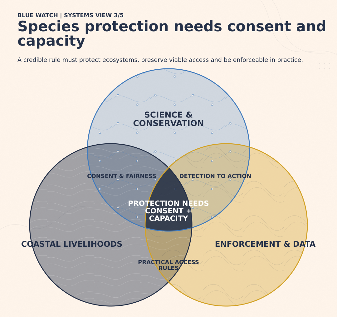
The Blue Watch read
Marine species protection determines who may fish, where they may operate and which livelihoods must adapt. This week’s measures ranged from whale habitat and salmon closures to international tuna access and action against illegal fishing. Together, they show that a scientifically credible rule also needs social legitimacy, enforcement capacity and a practical route from detection to lawful action.
Signals from the week
NOAA rejected a petition to designate a North Atlantic right whale migration corridor as critical habitat because the available evidence did not establish a sufficiently discrete route. The underlying protection challenge will continue through vessel-speed controls, monitoring, gear requirements and other measures.
Yukon closures affecting Chinook, fall chum and coho salmon retained limited access to non-salmon species fishing through selective gear. These provisions seek to preserve some subsistence access while protecting depleted stocks.
The renewed EU-Seychelles fisheries protocol provides EU vessels with tuna-fishing opportunities in exchange for payments, shipowner fees, sectoral support and environmental and labour commitments.
Sri Lanka detained nine Indian fishers near Talaimannar, prompting fishing associations in Rameswaram to begin a three-day boycott. One patrol encounter consequently became a fisheries, livelihood and bilateral-relations issue.
Maharashtra reversed its extension of the monsoon fishing closure shortly before the 1 August reopening. Traditional Koli fishers said poor communication left them unprepared and gave larger trawlers an unfair head start.
Authorities in Newfoundland brought charges linked to illegal nets targeting Atlantic salmon. The case required surveillance, interception, evidence collection and prosecution.
China deployed coastguard vessels for a high-seas patrol against illegal, unreported and unregulated fishing, adding another mission to an already broad portfolio of maritime enforcement tasks.
Six months after the EU’s CATCH digital certification system became mandatory, industry representatives and campaigners continued to raise concerns about delays, exemptions and administrative burden. Its value will depend on whether it identifies false documentation and prevents illegally caught seafood from entering the market.
The unresolved issue
Conservation measures allocate both benefits and burdens.
Consultation matters because restrictions can affect food access, household income and established fishing practices. Selective exemptions may reduce those effects, but only if the permitted access is practical and communities participate meaningfully in decisions about timing, location and gear.
Maharashtra shows how inconsistent communication can turn formally equal access into unequal access. Fishers who planned maintenance and crewing around the later date were placed at an immediate disadvantage to better-resourced operators.
Enforcement determines whether the rule has credibility. Patrol vessels assigned to fisheries protection may also be responsible for search and rescue, border control, pollution response, disaster support and sovereignty missions. Every new restriction creates requirements for surveillance, interception, evidence handling and prosecution. It rarely arrives with a dedicated vessel and crew.
Technology can reduce part of that burden. Satellite imagery, electronic monitoring, vessel tracking and digital catch certificates can identify suspicious behaviour and direct inspections towards higher-risk activity. Their usefulness depends on reliable data, compatible systems and an authority able to turn an alert into lawful enforcement.
CATCH will therefore need to be judged through outcomes. The relevant questions are whether it detects fraud, improves traceability, supports targeted inspections and reduces access to the European market for illegally caught seafood. The number of certificates processed says little by itself.
The larger challenge is to combine ecological recovery, viable coastal livelihoods and credible enforcement in the same policy. Treating them as separate objectives leaves the cost of protection unresolved.
4. Maritime data needs rules before it becomes trust
Question:When does information sharing strengthen cooperation, and when does it create a security or sovereignty risk?
The Blue Watch read
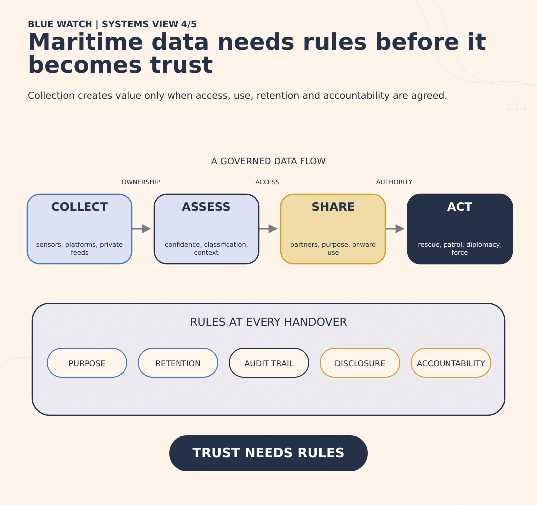
Maritime data can support surveillance, scientific research, military cooperation and lifesaving operations. It can also expose operational patterns, sharpen territorial disputes or place strategically significant information in private hands. The decisive issue is governance: who collects the data, who receives it, what they may do with it and who remains accountable when it produces consequences.
Signals from the week
The Netherlands selected a containerised anti-submarine surveillance capability designed for deployment from crewed and uncrewed vessels. Portable sensors can distribute collection across more platforms, but they also create questions about data ownership, contact classification and authority to act.
Australian P-8A aircraft operated from Royal Malaysian Air Force Butterworth during Operation Gateway, with Malaysian support and observers. The arrangement provides a structured model for joint maritime awareness while requiring agreement over access, retention and use of collected information.
Australia withheld documents concerning port access and US correspondence relating to the Chinese icebreakers Xue Long and Xue Long 2, citing national-security and international-relations concerns. Their scientific role does not remove the strategic sensitivity associated with dual-use platforms and polar access.
A privately operated US sea drone filmed a Chinese destroyer inside the Philippine exclusive economic zone. Reuters verified the footage, approximate location and date, but the drone’s customer, tasking and relationship with Philippine authorities remain undisclosed.
RIMPAC continued experimentation with multinational information sharing, testing how participating forces build a common operational picture across different platforms and national systems.
China, Vietnam, the Philippines and nearby vessels contributed to the rescue of 48 people after the Vietnamese cargo ship Khoi Nguyen 18 sank near Fiery Cross Reef. Shared positions, communications and search information supported cooperation in contested waters.
The unresolved issue
“Data sharing” describes a chain of separate decisions.
Who collected the information? Who owns the raw feed? Which partners can access it? How long may it be retained? Can it be passed to a third party? How is uncertainty recorded? Which authority may act on the resulting assessment?
Trusted sharing requires access controls, audit trails, agreed confidence levels, purpose limitations and rules for onward disclosure. It also requires political judgement. States may share enough information for navigation or rescue while protecting intelligence sources, collection methods and operational intent.
Scientific research creates an especially difficult boundary. States need security rules that distinguish legitimate research from strategically sensitive collection without making scientific access dependent on unexplained or apparently arbitrary decisions.
Private platforms complicate the chain further. Footage gathered commercially can influence diplomatic messaging, reveal naval patterns or contribute to an incident between states. The company operating the system may therefore generate geopolitical consequences without holding public authority or being subject to the rules applied to government collection.
The rescue near Fiery Cross Reef shows the other side of the equation. States involved in a territorial dispute were able to share enough information to serve an immediate common purpose. The question is whether comparable rules and channels can support longer-term cooperation, or whether trust remains confined to individual emergencies.
5. Drones are redistributing maritime authority
Question: Who may observe, strike or neutralise when the platform is accessible, persistent and sometimes privately operated?
The Blue Watch read
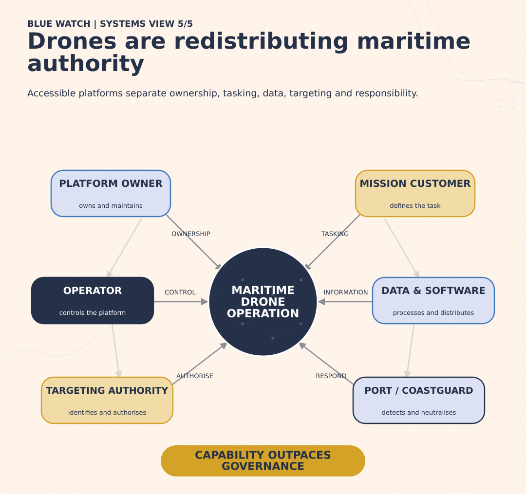
Maritime drones are spreading surveillance, strike and defensive capabilities across armed forces, coastguards and commercial operators. Their accessibility allows more actors to collect valuable information or affect operations at sea. Institutional arrangements are developing more slowly, leaving uncertainty over tasking, target identification, legal authority and responsibility when an incident escalates.
Signals from the week
New Zealand announced plans to acquire long-range, human-operated one-way strike drones while continuing separate research into uncrewed aircraft for maritime surveillance. Related technologies can therefore support maritime awareness, targeting, and strike.
A privately operated sea drone collected footage of a Chinese destroyer inside the Philippine EEZ. Its operator and customer remain undisclosed, despite the possible diplomatic and operational value of the data.
Iran said a Ukrainian drone strike against an Iranian vessel in the Caspian Sea killed one sailor and injured another. Ukraine subsequently acknowledged the strike and described it as unintentional. The vessel’s cargo, status and relationship to the intended target remain disputed.
Further Ukrainian drone attacks forced another suspension of tanker loadings at the CPC terminal near Novorossiysk. Although located in Russia, the terminal handles most Kazakh oil exports, extending the disruption well beyond the intended target.
Egypt confirmed that a drone caused the fire aboard the Energos Winter at Damietta, which spread to the Gaslog Salem. The attack has not been attributed and its intended target remains unknown.
The US Coast Guard requested information on commercially available systems capable of detecting, tracking and defeating uncrewed underwater vehicles in ports and harbours. The request is exploratory and does not yet constitute a procurement programme.
The unresolved issue
Drones separate functions that once sat more clearly inside a ship, aircraft or military unit.
A private company may own the platform. A software provider may process its data. A government customer may define the mission. Another state may control the waters or infrastructure being observed. Information can circulate publicly before the authorities involved have established what happened.
Strike operations require a clear chain from tasking to target identification and authorisation. The Caspian incident shows the consequences when that chain fails or produces an unintended result. Establishing the vessel’s identity, cargo and relationship to the intended target will be essential to understanding the legal and operational implications.
The CPC attacks blur the boundary between Russian infrastructure and third-country interests. Targeting a Russian export terminal also affects Kazakhstan, international investors, tanker crews and global energy markets.
Counter-drone operations create a parallel problem. Ports contain naval vessels, merchant shipping, energy terminals, pipelines and civilian traffic. Authorities need the ability to detect underwater systems, but detection alone does not establish hostile intent. A research vehicle, survey platform or lost civilian drone may initially resemble a threat.
Neutralisation therefore requires reliable identification, clear authority and a proportionate response. The Coast Guard, Navy, port operator and infrastructure owner may each hold part of the relevant information while remaining subject to different legal powers.
Drones can expand operational capacity rapidly. Developing the authority, accountability and incident-management arrangements around them will take longer.